Latest Posts

CRBC Proposes Construction of Bohdan T. Kulakowski Memorial Bikeway

Location of the proposed bikeway

CRBC is submitting requests to PennDOT and College and Harris Townships to begin the planning process for construction of a bike path along Warner Drive to connect the South Atherton Street Bikeway and the bike path from Mount Nittany Middle School to the planned Oak Hall Park.

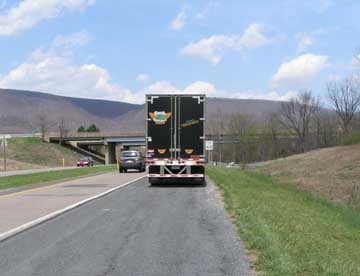
The proposed bikeway would allow cyclists and pedestrians to access the park from Boalsburg and State College via off-road paths. It would be located along the road (see photo) where Dr. Kulakowski was killed while cycling home from work on March 22 of this year. The proposal includes a rest stop and memorial for Dr. Kulakowski.


This project is part of CRBC’s program to develop complete streets (see completestreets.org) and to connect parks to communities via paths which will enhance safety and encourage everyone to explore and travel our community using their own power. Such paths will especially improve fitness and development of mobility and independence among children by allowing parents to urge them to navigate their community by bicycle.

We hope the improvement in health and quality of life produced by this path will serve as a fitting memorial to a dedicated cyclist who is missed by all who knew him.

Purdue Mountain Loop (25.0 miles)

If you are looking for some climbing, but only have a couple of hours to spare, this is the ride for you. After heading towards the airport, you will bear north on Fillmore Road and climb Bald Eagle Mountain. After a run along the ridge, offering occasional and spectacular views of the Allegheny front, you will descend to and through picturesque Bellefonte. A second (lesser) climb up Seibert Road will get you on your way back to the University Park Campus.


Total

Distance

Leg

Distance

Action

Comment

0.0

0.0

R / S

Turn right out of visitor’s center onto Porter Road.  Cross Park Ave. immediately, road becomes Fox Hollow Road.

2.0

2.0

BR

Fox Hollow bends right and becomes Fox Hill Road

3.5

1.5

L

Turn left onto Fillmore Road

4.7

1.2

S

Cross 550 (Buffalo Run Road) and start climbing

6.8

2.1

R

At the stop sign, turn right onto Purdue Mountain Road.

12.5

5.7

BL

At the stop sign, bear left onto Valley View Road.  (Variation: turn right onto Valley View Road and ride back to Fillmore Road.)

12.8

0.3

BL / S

Bear left at the first intersection and then continue straight at the second on Upper Coleville Road

13.8

1.0

S

Cross Lamb Street.  A convenience store will be on your left.  The historic Gamble Mill Tavern will also be on your left.

14.0

0.1

L

Turn left on West High Street

14.0

0.0

R

Turn right on North Potter Street (just before RR tracks), which becomes Slaughterhouse Road.

15.3

1.3

S

Cross 550.

15.6

0.3

BR

Bear right onto Seibert Road and start climbing.

18.9

3.2

L

Turn left at the T onto Rock Road.

19.3

0.4

S

Pass through stop sign at Fox Hill Road and begin descent.  Note: sharp right turn at bottom.

21.9

2.6

R

At stop sign, turn right onto Houserville Road.

22.7

0.8

R

Right at Puddintown Road.

23.6

0.9

R

Right onto Orchard Road.

24.5

0.9

L

Left onto Park Ave.

24.9

0.4

L

Left onto Porter Road.

25.0

0.1

L

Left into visitor center’s parking lot!

PHP Code Snippets Powered By : XYZScripts.com